
Thank you for supporting this site ❤️
Make a donation
Make a donation
Gear up for your next adventure:
As an Amazon Associate, this site earns from qualifying purchases at no extra cost to you.
Zenata topographic map
Click on the map to display elevation.
Thank you for supporting this site ❤️
Make a donation
Make a donation
Gear up for your next adventure:
As an Amazon Associate, this site earns from qualifying purchases at no extra cost to you.
About this map
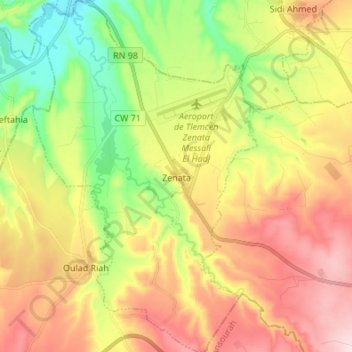
Name: Zenata topographic map, elevation, terrain.
Location: Zenata, Daïra Hennaya, Tlemcen, Algérie (34.93430 -1.51992 35.04557 -1.43139)
Average elevation: 873 ft
Minimum elevation: 338 ft
Maximum elevation: 1,460 ft
Thank you for supporting this site ❤️
Make a donation
Make a donation
Gear up for your next adventure:
As an Amazon Associate, this site earns from qualifying purchases at no extra cost to you.