Geolocate

Sumter topographic map

Click on the map to display elevation.

About this map

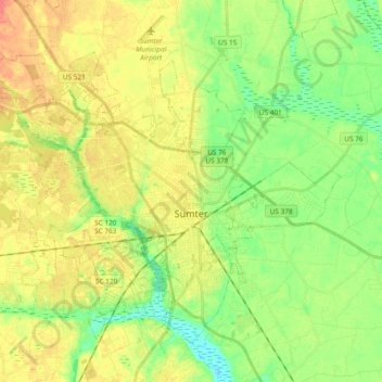
Name: Sumter topographic map, elevation, terrain.

Location: Sumter, Sumter County, South Carolina, United States (33.86331 -80.49367 33.99540 -80.30607)

Average elevation: 157 ft

Minimum elevation: 89 ft

Maximum elevation: 226 ft

Sumter County trails, hiking, mountain biking, running and outdoor activities

Other topographic maps

Click on a map to view its topography, its elevation and its terrain.

Ivey Hall

United States > South Carolina > Sumter County > Sumter

Average elevation: 148 ft

Swinton

United States > South Carolina > Sumter County

Average elevation: 187 ft

Gear up for your next adventure:

🌡️Portable Weather Meter - Track weather conditions on the trail
📌Outdoor GPS Map App - Apps and devices for digital topographic navigation
🛏️Cold Weather Sleeping Bag - Warm sleeping bag for cold conditions
🪶Survival Guide Book - Expert advice for emergency preparedness
🪓Survival Multi‑Tool - Versatile tool for camp and trail tasks

As an Amazon Associate, this site earns from qualifying purchases at no extra cost to you.