
Make a donation
Gear up for your next adventure:
As an Amazon Associate, this site earns from qualifying purchases at no extra cost to you.
Dreiborn topographic map
Click on the map to display elevation.
Make a donation
Gear up for your next adventure:
As an Amazon Associate, this site earns from qualifying purchases at no extra cost to you.
Dreiborn
Touristisch interessant sind die Höhenlage mit weitem Fernblick, der Nationalpark Eifel, die Dreiborner Hochfläche, die Nähe zur Olef- und Urfttalsperre, die Vielzahl der markierten Wander- und Radwege und die Anbindung an das ÖPNV-Netz des VRS.
Make a donation
Gear up for your next adventure:
As an Amazon Associate, this site earns from qualifying purchases at no extra cost to you.
About this map
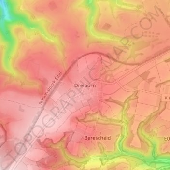
Name: Dreiborn topographic map, elevation, terrain.
Average elevation: 1,722 ft
Minimum elevation: 1,093 ft
Maximum elevation: 1,982 ft
Make a donation
Gear up for your next adventure:
As an Amazon Associate, this site earns from qualifying purchases at no extra cost to you.
Other topographic maps
Click on a map to view its topography, its elevation and its terrain.
53937
Deutschland > Nordrhein-Westfalen > Kreis Euskirchen > Schleiden > Morsbach
Average elevation: 1,647 ft