
Make a donation
Gear up for your next adventure:
As an Amazon Associate, this site earns from qualifying purchases at no extra cost to you.
Vreren topographic map
Click on the map to display elevation.
Make a donation
Gear up for your next adventure:
As an Amazon Associate, this site earns from qualifying purchases at no extra cost to you.
Vreren
De dorpskom concentreert zich rond de Sint-Medarduskerk in de vallei van de Buthbeek. Door lintbebouwing langs deze kleine waterloop sluit de bebouwing van Vreren aan op zowel de dorpskom van Diets-Heur als die van Nerem. Buiten de bebouwde kom loopt de hoogte op en leiden kleine veldwegen naar het Haspengouws Plateau.
Make a donation
Gear up for your next adventure:
As an Amazon Associate, this site earns from qualifying purchases at no extra cost to you.
About this map
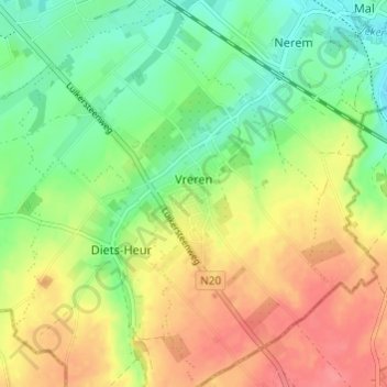
Name: Vreren topographic map, elevation, terrain.
Location: Vreren, Tongeren, Limburg, België (50.73142 5.46842 50.76973 5.51775)
Average elevation: 371 ft
Minimum elevation: 269 ft
Maximum elevation: 489 ft
Make a donation
Gear up for your next adventure:
As an Amazon Associate, this site earns from qualifying purchases at no extra cost to you.