
Make a donation
Gear up for your next adventure:
As an Amazon Associate, this site earns from qualifying purchases at no extra cost to you.
Krakow topographic map
Click on the map to display elevation.
Make a donation
Gear up for your next adventure:
As an Amazon Associate, this site earns from qualifying purchases at no extra cost to you.
About this map
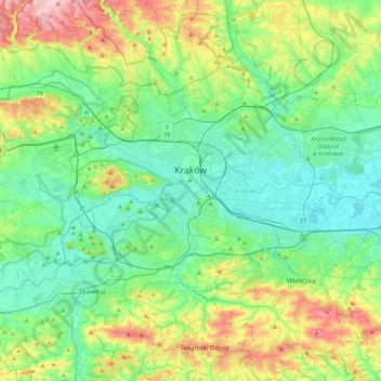
Name: Krakow topographic map, elevation, terrain.
Location: Krakow, Lesser Poland Voivodeship, Poland (49.96767 19.79224 50.12613 20.21735)
Average elevation: 863 ft
Minimum elevation: 620 ft
Maximum elevation: 1,539 ft
Make a donation
Gear up for your next adventure:
As an Amazon Associate, this site earns from qualifying purchases at no extra cost to you.
Other topographic maps
Click on a map to view its topography, its elevation and its terrain.
Koszarka
Poland > Lesser Poland Voivodeship > Nowy Sącz County > Gródek nad Dunajcem
Average elevation: 1,076 ft
Morskie Oko
Poland > Lesser Poland Voivodeship > Tatra County > Brzegi
Morskie Oko at the foothill of Tatra Mountains in southern Poland which average 2,000 metres (6,600 ft) in elevation
Average elevation: 5,738 ft
Make a donation
Gear up for your next adventure:
As an Amazon Associate, this site earns from qualifying purchases at no extra cost to you.
Rysy
Poland > Lesser Poland Voivodeship > Tatra County > Brzegi
It is possible to reach the peak from the Slovak side, starting at Štrbské pleso and passing Chata pod Rysmi, a mountain chalet at an altitude of 2,250 m (7,380 ft). Between November 1 and June 15, the trail and chalet on the Slovak side are closed.
Average elevation: 6,578 ft
Water
Poland > Lesser Poland Voivodeship > Limanowa County > Poręba Wielka
Average elevation: 2,533 ft
Czarny Staw Polski
Poland > Lesser Poland Voivodeship > Tatra County > Brzegi
Average elevation: 5,938 ft
Make a donation
Gear up for your next adventure:
As an Amazon Associate, this site earns from qualifying purchases at no extra cost to you.
Gęsia Szyja
Poland > Lesser Poland Voivodeship > Tatra County > Małe Ciche
Average elevation: 4,245 ft
Rzeszotary Górne
Poland > Lesser Poland Voivodeship > Kraków County > Rzeszotary
Average elevation: 1,089 ft
Make a donation
Gear up for your next adventure:
As an Amazon Associate, this site earns from qualifying purchases at no extra cost to you.
Palenica
Poland > Lesser Poland Voivodeship > Nowy Targ County > Szczawnica
Average elevation: 1,827 ft
Make a donation
Gear up for your next adventure:
As an Amazon Associate, this site earns from qualifying purchases at no extra cost to you.
Buczkówka
Poland > Lesser Poland Voivodeship > Tarnów County > Szczepanowice
Average elevation: 1,001 ft
Dąbry
Poland > Lesser Poland Voivodeship > Wadowice County > Stanisław Górny
Average elevation: 1,122 ft
Buczkówka
Poland > Lesser Poland Voivodeship > Tarnów County > Szczepanowice
Average elevation: 1,001 ft
Make a donation
Gear up for your next adventure:
As an Amazon Associate, this site earns from qualifying purchases at no extra cost to you.
Podkościele
Poland > Lesser Poland Voivodeship > Tarnów County > Poręba Radlna
Average elevation: 876 ft
Make a donation
Gear up for your next adventure:
As an Amazon Associate, this site earns from qualifying purchases at no extra cost to you.
966
Poland > Lesser Poland Voivodeship > Wieliczka County > Lednica Górna > Świdówka
Average elevation: 1,165 ft
Pieniny
Poland > Lesser Poland Voivodeship > Nowy Targ County > Sromowce Niżne
Average elevation: 2,077 ft
Sicica
Poland > Lesser Poland Voivodeship > Tarnów County > Zbylitowska Góra
Average elevation: 669 ft
Make a donation
Gear up for your next adventure:
As an Amazon Associate, this site earns from qualifying purchases at no extra cost to you.
Three Crowns
Poland > Lesser Poland Voivodeship > Nowy Targ County > Sromowce Niżne > Koniec
Average elevation: 2,096 ft
Make a donation
Gear up for your next adventure:
As an Amazon Associate, this site earns from qualifying purchases at no extra cost to you.
Bochenkowa Dolina
Poland > Lesser Poland Voivodeship > Wadowice County > Skawce
Average elevation: 1,175 ft
Make a donation
Gear up for your next adventure:
As an Amazon Associate, this site earns from qualifying purchases at no extra cost to you.
Zawrocie
Poland > Lesser Poland Voivodeship > Brzesko County > Wytrzyszczka
Average elevation: 1,010 ft
Rysy
Poland > Lesser Poland Voivodeship > Tatra County > Brzegi
It is possible to reach the peak from the Slovak side, starting at Štrbské pleso and passing Chata pod Rysmi, a mountain chalet at an altitude of 2,250 m (7,380 ft). Between November 1 and June 1, the trail and chalet on the Slovak side are closed.
Average elevation: 6,578 ft
Make a donation
Gear up for your next adventure:
As an Amazon Associate, this site earns from qualifying purchases at no extra cost to you.
Podzamcze
Poland > Lesser Poland Voivodeship > Kraków County > Korzkiew > Podzamcze
Average elevation: 1,053 ft
Tatry
Poland > Lesser Poland Voivodeship > Tatra County > Zakopane
The Tatras lie in the temperate zone of Central Europe. They are an important barrier to the movements of air masses. Their mountainous topography causes one of the most diverse climates in that region.
Average elevation: 5,404 ft
Make a donation
Gear up for your next adventure:
As an Amazon Associate, this site earns from qualifying purchases at no extra cost to you.
Krowiarki
Poland > Lesser Poland Voivodeship > Nowy Targ County > Chochołów
Average elevation: 2,740 ft
Ciptowski
Poland > Lesser Poland Voivodeship > Nowy Targ County > Łapszanka
Average elevation: 2,946 ft
Stasindowie
Poland > Lesser Poland Voivodeship > Tatra County > Gliczarów Górny
Average elevation: 2,933 ft
Make a donation
Gear up for your next adventure:
As an Amazon Associate, this site earns from qualifying purchases at no extra cost to you.
Obidowa
Poland > Lesser Poland Voivodeship > Nowy Targ County
The summit of Turbacz has a subarctic climate (Köppen Dfc) due to its elevation. The average temperatures are comparable with those found in places in far Northern Europe, such as Alta, Norway, however, the high annual precipitation in combination with the low temperatures places it firmly within the…
Average elevation: 3,665 ft
Dwudniaki
Poland > Lesser Poland Voivodeship > Tarnów County > Wierzchosławice
Average elevation: 630 ft
Make a donation
Gear up for your next adventure:
As an Amazon Associate, this site earns from qualifying purchases at no extra cost to you.
Grzechynia Dolna
Poland > Lesser Poland Voivodeship > Sucha County > Grzechynia
Average elevation: 1,483 ft
Myślenice
Poland > Lesser Poland Voivodeship > Myślenice County > Myślenice > Myślenice
Average elevation: 1,227 ft
Kaniówka
Poland > Lesser Poland Voivodeship > Tatra County > Białka Tatrzańska
Average elevation: 2,605 ft
Make a donation
Gear up for your next adventure:
As an Amazon Associate, this site earns from qualifying purchases at no extra cost to you.
Parcel
Poland > Lesser Poland Voivodeship > powiat miechowski > Strzeżów Drugi
Average elevation: 1,089 ft
Make a donation
Gear up for your next adventure:
As an Amazon Associate, this site earns from qualifying purchases at no extra cost to you.
Czułówek
Poland > Lesser Poland Voivodeship > Kraków County > Czułówek > Czułówek
Average elevation: 866 ft
Czchów
Poland > Lesser Poland Voivodeship > Brzesko County > Czchów > Czchów
Average elevation: 971 ft
Wielki Giewont
Poland > Lesser Poland Voivodeship > Tatra County > Zakopane
Average elevation: 4,849 ft
Make a donation
Gear up for your next adventure:
As an Amazon Associate, this site earns from qualifying purchases at no extra cost to you.
Babia Góra / Babia hora
Poland > Lesser Poland Voivodeship > Sucha County > Zawoja
Gentle from the south, steep from the north, Babia Góra is home to bear, lynx, wolf and other species; as well as alpine flora endemic at this altitude. The first attempts to protect the area were made in the 1930s. In 1933 the Nature Reserve of Babia Góra was established on the Polish side. Later, in 1954,…
Average elevation: 4,577 ft
Make a donation
Gear up for your next adventure:
As an Amazon Associate, this site earns from qualifying purchases at no extra cost to you.