
Make a donation
Gear up for your next adventure:
As an Amazon Associate, this site earns from qualifying purchases at no extra cost to you.
Asco topographic map
Click on the map to display elevation.
Make a donation
Gear up for your next adventure:
As an Amazon Associate, this site earns from qualifying purchases at no extra cost to you.
Asco
Asco people live at an average altitude in the village of 600 metres. The village dates from the 11th century. Many older homes have been renovated and are enclosed in the lower part of the village where the parish church of St. Michael the Archangel with its typical bell tower and the War memorial are located.
Make a donation
Gear up for your next adventure:
As an Amazon Associate, this site earns from qualifying purchases at no extra cost to you.
About this map
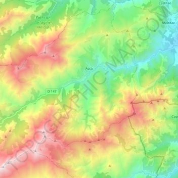
Name: Asco topographic map, elevation, terrain.
Average elevation: 4,078 ft
Minimum elevation: 951 ft
Maximum elevation: 8,816 ft
Make a donation
Gear up for your next adventure:
As an Amazon Associate, this site earns from qualifying purchases at no extra cost to you.