
Make a donation
Gear up for your next adventure:
As an Amazon Associate, this site earns from qualifying purchases at no extra cost to you.
Timimoun topographic map
Click on the map to display elevation.
Make a donation
Gear up for your next adventure:
As an Amazon Associate, this site earns from qualifying purchases at no extra cost to you.
About this map
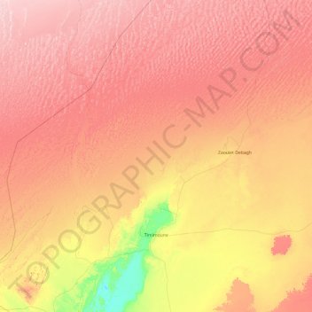
Name: Timimoun topographic map, elevation, terrain.
Location: Timimoun, Timimoun District, Timimoun Province, Algeria (28.98233 0.10222 30.38032 2.02257)
Average elevation: 1,407 ft
Minimum elevation: 1,017 ft
Maximum elevation: 1,988 ft
Make a donation
Gear up for your next adventure:
As an Amazon Associate, this site earns from qualifying purchases at no extra cost to you.
Other topographic maps
Click on a map to view its topography, its elevation and its terrain.
Timimoun
Algeria > Timimoun Province > Timimoun District
The town of Timimoun lies at an elevation of around 288 metres (945 ft) in the Gourara region of southern Timimoun Province. It is located on the south-eastern side of an oasis which supports the town's population. A sebkha (salt lake) lies further to the northwest, while the plateau of Tademaït rises to the…
Average elevation: 899 ft