
Thank you for supporting this site ❤️
Make a donation
Make a donation
Gear up for your next adventure:
As an Amazon Associate, this site earns from qualifying purchases at no extra cost to you.
Mesillas topographic map
Click on the map to display elevation.
Thank you for supporting this site ❤️
Make a donation
Make a donation
Gear up for your next adventure:
As an Amazon Associate, this site earns from qualifying purchases at no extra cost to you.
About this map
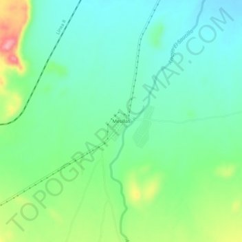
Name: Mesillas topographic map, elevation, terrain.
Location: Mesillas, Ramos Arizpe, Coahuila, Mexico (25.78312 -101.00990 25.82312 -100.96990)
Average elevation: 3,038 ft
Minimum elevation: 2,920 ft
Maximum elevation: 3,314 ft
Thank you for supporting this site ❤️
Make a donation
Make a donation
Gear up for your next adventure:
As an Amazon Associate, this site earns from qualifying purchases at no extra cost to you.