
Make a donation
Gear up for your next adventure:
As an Amazon Associate, this site earns from qualifying purchases at no extra cost to you.
Gallipolis topographic map
Click on the map to display elevation.
Make a donation
Gear up for your next adventure:
As an Amazon Associate, this site earns from qualifying purchases at no extra cost to you.
Gallipolis
Winters are cold, with an average January temperature of 34.3 °F (1.3 °C). Snowfall is generally very light, with a mean average snowfall of 10.9 inches (280 mm). The village does not experience by lake-effect snow, although the village's weather can be influenced by the Great Lakes and regional topography. On average, there are 109 nights per year when the temperature drops to or below freezing, and only 14 days when the temperature fails to rise above freezing. Summers are hot and humid, with an average July temperature of 78.6 °F (25.9 °C). There are an average of 39 days per year with highs at or above 90 °F (32 °C).
Make a donation
Gear up for your next adventure:
As an Amazon Associate, this site earns from qualifying purchases at no extra cost to you.
About this map
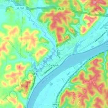
Name: Gallipolis topographic map, elevation, terrain.
Location: Gallipolis, Gallia County, Ohio, United States (38.79311 -82.22809 38.83919 -82.14937)
Average elevation: 666 ft
Minimum elevation: 541 ft
Maximum elevation: 912 ft
Gallia County trails, hiking, mountain biking, running and outdoor activities
Make a donation
Gear up for your next adventure:
As an Amazon Associate, this site earns from qualifying purchases at no extra cost to you.
Other topographic maps
Click on a map to view its topography, its elevation and its terrain.
Make a donation
Gear up for your next adventure:
As an Amazon Associate, this site earns from qualifying purchases at no extra cost to you.