
Make a donation
Gear up for your next adventure:
As an Amazon Associate, this site earns from qualifying purchases at no extra cost to you.
Confluence topographic map
Click on the map to display elevation.
Make a donation
Gear up for your next adventure:
As an Amazon Associate, this site earns from qualifying purchases at no extra cost to you.
About this map
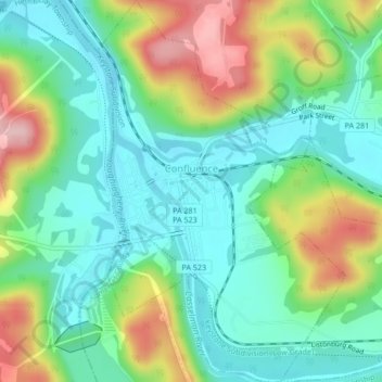
Name: Confluence topographic map, elevation, terrain.
Average elevation: 1,506 ft
Minimum elevation: 1,289 ft
Maximum elevation: 1,946 ft
Somerset County trails, hiking, mountain biking, running and outdoor activities
Make a donation
Gear up for your next adventure:
As an Amazon Associate, this site earns from qualifying purchases at no extra cost to you.
Other topographic maps
Click on a map to view its topography, its elevation and its terrain.
Boone
United States > Pennsylvania > Somerset County > Stonycreek Township
Average elevation: 2,392 ft
Barronvale
United States > Pennsylvania > Somerset County > Middlecreek Township
Average elevation: 1,982 ft
Flight 93 National Memorial
United States > Pennsylvania > Somerset County > Stonycreek Township
Average elevation: 2,392 ft
Make a donation
Gear up for your next adventure:
As an Amazon Associate, this site earns from qualifying purchases at no extra cost to you.
Cairnbrook
United States > Pennsylvania > Somerset County > Shade Township
Average elevation: 2,274 ft
Zimmerman
United States > Pennsylvania > Somerset County > Somerset Township
Average elevation: 2,142 ft
Make a donation
Gear up for your next adventure:
As an Amazon Associate, this site earns from qualifying purchases at no extra cost to you.
Tire Hill
United States > Pennsylvania > Somerset County > Conemaugh Township
Average elevation: 1,529 ft
2768 feet
United States > Pennsylvania > Somerset County > Jefferson Township
Average elevation: 2,661 ft