
Make a donation
Gear up for your next adventure:
As an Amazon Associate, this site earns from qualifying purchases at no extra cost to you.
Alberdi topographic map
Click on the map to display elevation.
Make a donation
Gear up for your next adventure:
As an Amazon Associate, this site earns from qualifying purchases at no extra cost to you.
About this map
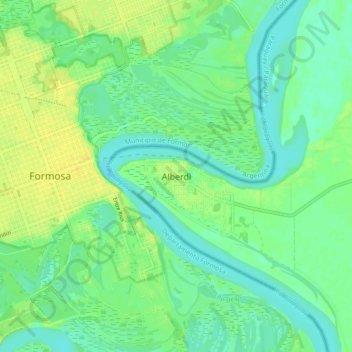
Name: Alberdi topographic map, elevation, terrain.
Location: Alberdi, Ñeembucú, Región Oriental, 2980, Paraguay (-26.22541 -58.18249 -26.14541 -58.10249)
Average elevation: 184 ft
Minimum elevation: 154 ft
Maximum elevation: 223 ft
Make a donation
Gear up for your next adventure:
As an Amazon Associate, this site earns from qualifying purchases at no extra cost to you.
Other topographic maps
Click on a map to view its topography, its elevation and its terrain.
Cerrito
Su nombre proviene de un pequeño cerro desde el cual se tiene una hermosa vista del río. Esta elevación tiene como nombre Ita Punta. En su cima tenía un busto del dictador Alfredo Stroessner que fue destruido por un rayo poco antes del golpe de Estado que lo derrocó. El rayo dio origen a investigación…
Average elevation: 190 ft