Geolocate

Olongapo topographic map

Click on the map to display elevation.

About this map

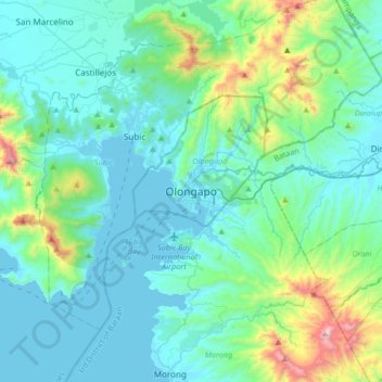
Name: Olongapo topographic map, elevation, terrain.

Location: Olongapo, Zambales, Central Luzon, 2200, Philippines (14.67147 120.12352 14.99147 120.44352)

Average elevation: 636 ft

Minimum elevation: -10 ft

Maximum elevation: 4,055 ft

Gear up for your next adventure:

📷Action Camera - Capture your outdoor adventures in HD
🔭Telescopic Hiking Pole - Adjustable pole for hiking stability
🧭Map Reading Tools - Tools and kits for map navigation
🪶Compact Camp Shovel - Folding shovel for campsite tasks
🔭Stargazing Telescopes - Perfect for camping in low-light pollution areas shown on maps

As an Amazon Associate, this site earns from qualifying purchases at no extra cost to you.