
Make a donation
Gear up for your next adventure:
As an Amazon Associate, this site earns from qualifying purchases at no extra cost to you.
Sangüesa topographic map
Click on the map to display elevation.
Make a donation
Gear up for your next adventure:
As an Amazon Associate, this site earns from qualifying purchases at no extra cost to you.
Sangüesa
El terreno que compone el municipio por lo general es llano y está atravesado de norte a sur por el río Aragón, que forma una vega y baña la capital del municipio, la cual está situada a una altitud de 404 m sobre el nivel del mar. Al río Aragón afluyen el Irati en el extremo norte y el Onsella al este. La cota máxima de altitud se da en el monte Ugarte (627 m), situado en el límite con Liédena.
Make a donation
Gear up for your next adventure:
As an Amazon Associate, this site earns from qualifying purchases at no extra cost to you.
About this map
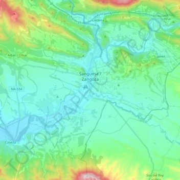
Name: Sangüesa topographic map, elevation, terrain.
Location: Sangüesa, Comarca de Sangüesa, Navarra, 31400, España (42.51096 -1.34786 42.61865 -1.15803)
Average elevation: 1,667 ft
Minimum elevation: 1,234 ft
Maximum elevation: 3,471 ft
Make a donation
Gear up for your next adventure:
As an Amazon Associate, this site earns from qualifying purchases at no extra cost to you.
Other topographic maps
Click on a map to view its topography, its elevation and its terrain.
Make a donation
Gear up for your next adventure:
As an Amazon Associate, this site earns from qualifying purchases at no extra cost to you.