
Make a donation
Gear up for your next adventure:
As an Amazon Associate, this site earns from qualifying purchases at no extra cost to you.
Mount Kinyeti topographic map
Click on the map to display elevation.
Make a donation
Gear up for your next adventure:
As an Amazon Associate, this site earns from qualifying purchases at no extra cost to you.
Mount Kinyeti
Mount Kinyeti is the highest peak in South Sudan. It is located in the Imatong Mountains in Ikotos County of Eastern Equatoria, near the Ugandan border. Kinyeti has an elevation of 3,187 metres (10,456 ft) above sea level. The group of high mountains that contain Kinyeti, extending to the border with Uganda, are sometimes called the Lomariti or Lolobai mountains.
Make a donation
Gear up for your next adventure:
As an Amazon Associate, this site earns from qualifying purchases at no extra cost to you.
About this map
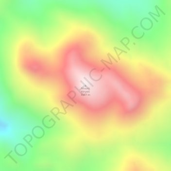
Name: Mount Kinyeti topographic map, elevation, terrain.
Location: Mount Kinyeti, Ikotos, Eastern Equatoria, South Sudan (3.94606 32.91023 3.94616 32.91033)
Average elevation: 9,413 ft
Minimum elevation: 8,271 ft
Maximum elevation: 10,417 ft
Make a donation
Gear up for your next adventure:
As an Amazon Associate, this site earns from qualifying purchases at no extra cost to you.