Geolocate

Rosemount topographic map

Click on the map to display elevation.

About this map

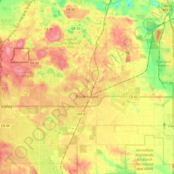
Name: Rosemount topographic map, elevation, terrain.

Location: Rosemount, Dakota County, Minnesota, 55068, United States (44.71680 -93.15854 44.77575 -92.97425)

Average elevation: 942 ft

Minimum elevation: 771 ft

Maximum elevation: 1,076 ft

Dakota County trails, hiking, mountain biking, running and outdoor activities

Other topographic maps

Click on a map to view its topography, its elevation and its terrain.

Pickerel Lake

United States > Minnesota > Dakota County > Lilydale

Average elevation: 827 ft

Hastings

United States > Minnesota > Dakota County

Average elevation: 797 ft

Hastings

United States > Minnesota > Dakota County

Average elevation: 797 ft

Coates

United States > Minnesota > Dakota County > Coates > Coates

Average elevation: 919 ft

Empire Lake

United States > Minnesota > Dakota County

Average elevation: 909 ft

Gear up for your next adventure:

🔭Stargazing Telescopes - Perfect for camping in low-light pollution areas shown on maps
🧦Merino Wool Socks - Moisture-wicking, blister-preventing socks for long treks
🛰️Handheld GPS Units - Professional satellite navigators for precise backcountry mapping
🎒Day Hiking Backpack - Lightweight backpack perfect for day trips and outdoor adventures
🗺️NatGeo Topo Maps - High-quality waterproof printed topographic maps of US Parks

As an Amazon Associate, this site earns from qualifying purchases at no extra cost to you.