
Make a donation
Gear up for your next adventure:
As an Amazon Associate, this site earns from qualifying purchases at no extra cost to you.
Burkardroth topographic map
Click on the map to display elevation.
Make a donation
Gear up for your next adventure:
As an Amazon Associate, this site earns from qualifying purchases at no extra cost to you.
About this map
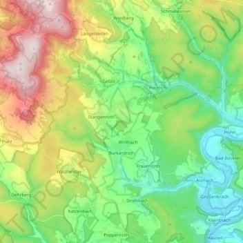
Name: Burkardroth topographic map, elevation, terrain.
Location: Burkardroth, Landkreis Bad Kissingen, Bavaria, 97705, Germany (50.22573 9.90132 50.34494 10.06483)
Average elevation: 1,381 ft
Minimum elevation: 656 ft
Maximum elevation: 2,756 ft
Make a donation
Gear up for your next adventure:
As an Amazon Associate, this site earns from qualifying purchases at no extra cost to you.
Other topographic maps
Click on a map to view its topography, its elevation and its terrain.
Wermerichshausen
Germany > Bavaria > Landkreis Bad Kissingen > Münnerstadt
Average elevation: 1,024 ft
Hammelburg
Germany > Bavaria > Landkreis Bad Kissingen > Hammelburg > Hammelburg
Average elevation: 853 ft
Make a donation
Gear up for your next adventure:
As an Amazon Associate, this site earns from qualifying purchases at no extra cost to you.
Bad Kissingen
Germany > Bavaria > Landkreis Bad Kissingen > Bad Kissingen > Bad Kissingen
Average elevation: 968 ft