Geolocate

Pianing topographic map

Click on the map to display elevation.

About this map

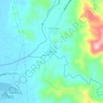
Name: Pianing topographic map, elevation, terrain.

Location: Pianing, Butuan, Caraga, Philippines (8.96654 125.62159 9.00654 125.66159)

Average elevation: 292 ft

Minimum elevation: 52 ft

Maximum elevation: 1,204 ft

Gear up for your next adventure:

🎒Waterproof Dry Bags - Keep your electronics and maps dry inside your pack
🔥Camping Stove - Portable stove for camping and backcountry cooking
🍳Camping Cook Set - Complete cookware for outdoor meals
🦟Ultrasonic Repellers - Create a bug-free zone at your camp or rest stop
🧭Compass with Lanyard - Easy‑carry compass for navigation

As an Amazon Associate, this site earns from qualifying purchases at no extra cost to you.