
Kincardine topographic map
Interactive map
Click on the map to display elevation.
About this map
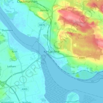
Name: Kincardine topographic map, elevation, terrain.
Location: Kincardine, Fife, Scotland, FK10 4NE, United Kingdom (56.02840 -3.75846 56.10840 -3.67846)
Average elevation: 72 ft
Minimum elevation: -10 ft
Maximum elevation: 338 ft
Other topographic maps
Click on a map to view its topography, its elevation and its terrain.
St Andrews
United Kingdom > Scotland > Fife
St Andrews, Fife, Scotland, KY16 9PA, United Kingdom
Average elevation: 125 ft
Kirkcaldy
United Kingdom > Scotland > Fife
Kirkcaldy, Fife, Scotland, KY1 1JA, United Kingdom
Average elevation: 164 ft
Glenrothes
United Kingdom > Scotland > Fife
Glenrothes, Fife, Scotland, KY7 5LW, United Kingdom
Average elevation: 348 ft
Freuchie
United Kingdom > Scotland > Fife
Freuchie, Fife, Scotland, KY15 7EJ, United Kingdom
Average elevation: 256 ft
Elie and Earlsferry
United Kingdom > Scotland > Fife > Elie and Earlsferry
Elie and Earlsferry, Fife, Scotland, KY9 1BD, United Kingdom
Average elevation: 33 ft
Falkland
United Kingdom > Scotland > Fife
Falkland, Fife, Scotland, KY15 7BU, United Kingdom
Average elevation: 436 ft