
Make a donation
Gear up for your next adventure:
As an Amazon Associate, this site earns from qualifying purchases at no extra cost to you.
Naast topographic map
Click on the map to display elevation.
Make a donation
Gear up for your next adventure:
As an Amazon Associate, this site earns from qualifying purchases at no extra cost to you.
Naast
La rivière appelée "la Senne" prend sa source sur le territoire de Naast près du point culminant de la commune de Soignies, vers 140 mètres d'altitude.
Make a donation
Gear up for your next adventure:
As an Amazon Associate, this site earns from qualifying purchases at no extra cost to you.
About this map
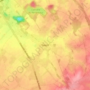
Name: Naast topographic map, elevation, terrain.
Location: Naast, Soignies, Hainaut, Wallonie, 7062, Belgique (50.53369 4.08117 50.57369 4.12117)
Average elevation: 341 ft
Minimum elevation: 135 ft
Maximum elevation: 440 ft
Make a donation
Gear up for your next adventure:
As an Amazon Associate, this site earns from qualifying purchases at no extra cost to you.
Other topographic maps
Click on a map to view its topography, its elevation and its terrain.
Chaussée-Notre-Dame-Louvignies
Belgique > Hainaut > Soignies > Soignies
Chaussée-Notre-Dame-Louvignies est situé à 6 kilomètres à l'ouest de Soignies. Le territoire est parcouru du sud au nord par l'ancienne voie romaine, dite Chaussée Brunehault, allant de Bavay à Utrecht. Le second village, Chaussée-Notre-Dame s'étire le long de l'ancienne chaussée, un peu au nord de…
Average elevation: 282 ft
Horrues
Belgique > Hainaut > Soignies > Soignies
La localité est un petit village de campagne. L'altitude varie entre 75 et 115 mètres. Bien que Horrues soit placé sur le plateau du Hainaut, le paysage est assez vallonné le long de la Senne. Le village est entouré de champs (betteraves, blé, maïs, pommes de terre, etc.)
Average elevation: 269 ft
Make a donation
Gear up for your next adventure:
As an Amazon Associate, this site earns from qualifying purchases at no extra cost to you.
Neufvilles
Belgique > Hainaut > Soignies > Soignies
Neufvilles est situé en milieu rural sur le plateau du Hainaut ce qui rend la zone assez plane. L'altitude varie entre 80 et 110 mètres. Le village est entouré de champs (betteraves, blé, maïs, pommes de terre, etc.). Du côté de Casteau, la zone appelée Neufvilles Gage est délimitée par des bois. Le…
Average elevation: 305 ft
Casteau
Belgique > Hainaut > Soignies > Soignies
Près de la rivière Aubrecheuil qui traverse la localité se trouve une vallée encaissée et verdoyante. Le cœur du village est bâti sur un promontoire tandis que le quartier des Bruyères est une plaine qui offre un habitat dispersé de maisons longues et basses entourées de haies typiques. Le village…
Average elevation: 322 ft