
Make a donation
Gear up for your next adventure:
As an Amazon Associate, this site earns from qualifying purchases at no extra cost to you.
Big Moose topographic map
Click on the map to display elevation.
Make a donation
Gear up for your next adventure:
As an Amazon Associate, this site earns from qualifying purchases at no extra cost to you.
About this map
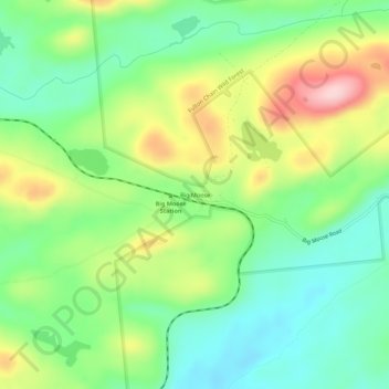
Name: Big Moose topographic map, elevation, terrain.
Average elevation: 2,034 ft
Minimum elevation: 1,778 ft
Maximum elevation: 2,467 ft
Herkimer County trails, hiking, mountain biking, running and outdoor activities
Make a donation
Gear up for your next adventure:
As an Amazon Associate, this site earns from qualifying purchases at no extra cost to you.
Other topographic maps
Click on a map to view its topography, its elevation and its terrain.
Thendara
United States > New York > Herkimer County > Old Forge > Thendara
Average elevation: 1,775 ft
Salisbury Center
United States > New York > Herkimer County > Town of Salisbury > Salisbury Center
Average elevation: 1,096 ft
Fulton Chain Wild Forest
United States > New York > Herkimer County > Old Forge
Average elevation: 1,913 ft
Make a donation
Gear up for your next adventure:
As an Amazon Associate, this site earns from qualifying purchases at no extra cost to you.
Village of Middleville
United States > New York > Herkimer County > Town of Fairfield
Average elevation: 745 ft
Village of Cold Brook
United States > New York > Herkimer County > Town of Russia
Average elevation: 1,073 ft
Make a donation
Gear up for your next adventure:
As an Amazon Associate, this site earns from qualifying purchases at no extra cost to you.
Make a donation
Gear up for your next adventure:
As an Amazon Associate, this site earns from qualifying purchases at no extra cost to you.
Make a donation
Gear up for your next adventure:
As an Amazon Associate, this site earns from qualifying purchases at no extra cost to you.
Village of Middleville
United States > New York > Herkimer County > Town of Fairfield
Average elevation: 745 ft
Salisbury Center
United States > New York > Herkimer County > Town of Salisbury > Salisbury Center
Average elevation: 1,106 ft
Make a donation
Gear up for your next adventure:
As an Amazon Associate, this site earns from qualifying purchases at no extra cost to you.