
Thank you for supporting this site ❤️
Make a donation
Make a donation
Gear up for your next adventure:
As an Amazon Associate, this site earns from qualifying purchases at no extra cost to you.
Barangay A topographic map
Click on the map to display elevation.
Thank you for supporting this site ❤️
Make a donation
Make a donation
Gear up for your next adventure:
As an Amazon Associate, this site earns from qualifying purchases at no extra cost to you.
About this map
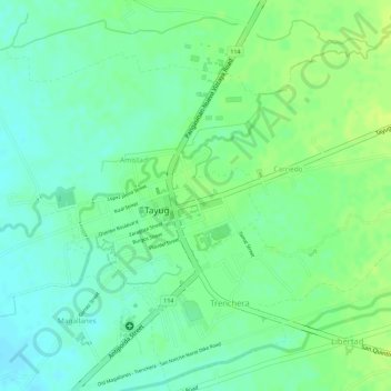
Name: Barangay A topographic map, elevation, terrain.
Location: Barangay A, Tayug, Pangasinan, Ilocos Region, Philippines (16.02505 120.74295 16.03208 120.75172)
Average elevation: 203 ft
Minimum elevation: 174 ft
Maximum elevation: 230 ft
Thank you for supporting this site ❤️
Make a donation
Make a donation
Gear up for your next adventure:
As an Amazon Associate, this site earns from qualifying purchases at no extra cost to you.