
Make a donation
Gear up for your next adventure:
As an Amazon Associate, this site earns from qualifying purchases at no extra cost to you.
Arctic Bay topographic map
Click on the map to display elevation.
Make a donation
Gear up for your next adventure:
As an Amazon Associate, this site earns from qualifying purchases at no extra cost to you.
Arctic Bay
Arctic Bay experiences a tundra climate (Köppen: ET) like most northern Canadian territories at low elevations, with long, very cold winters and short, cool to cold summers. July is the only month with an average low temperature above freezing. Its climate does not differ from the more severe subarctic climates except for the practically non-existent summer (even Svalbard, an island to the north, has much warmer summers). Even in summer, the average temperature at dawn can be below freezing. The amount of precipitation is of a desert climate, below 250 mm (9.8 in), and the days of snow is comparable to a coastal city of a lake or sea in the middle latitudes, but low for the location. Most precipitation is between summer and early fall. With the thawing process of permafrost, some communities such as Arctic Bay may be affected by flooding due to the melting of sea ice and erosion due to the mechanical process of temperature changes and their own variation.
Make a donation
Gear up for your next adventure:
As an Amazon Associate, this site earns from qualifying purchases at no extra cost to you.
About this map
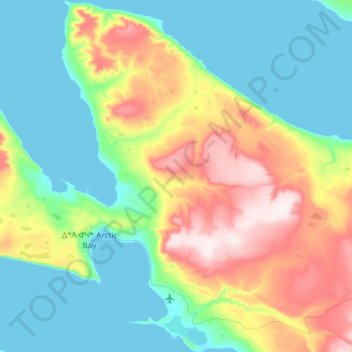
Name: Arctic Bay topographic map, elevation, terrain.
Location: Arctic Bay, Qikiqtaaluk Region, Nunavut, Canada (72.97645 -85.41647 73.15006 -84.91642)
Average elevation: 525 ft
Minimum elevation: 0 ft
Maximum elevation: 1,893 ft
Make a donation
Gear up for your next adventure:
As an Amazon Associate, this site earns from qualifying purchases at no extra cost to you.
Other topographic maps
Click on a map to view its topography, its elevation and its terrain.
Make a donation
Gear up for your next adventure:
As an Amazon Associate, this site earns from qualifying purchases at no extra cost to you.
Make a donation
Gear up for your next adventure:
As an Amazon Associate, this site earns from qualifying purchases at no extra cost to you.
Make a donation
Gear up for your next adventure:
As an Amazon Associate, this site earns from qualifying purchases at no extra cost to you.
Make a donation
Gear up for your next adventure:
As an Amazon Associate, this site earns from qualifying purchases at no extra cost to you.
Make a donation
Gear up for your next adventure:
As an Amazon Associate, this site earns from qualifying purchases at no extra cost to you.