
Hoquiam topographic map
Click on the map to display elevation.
About this map
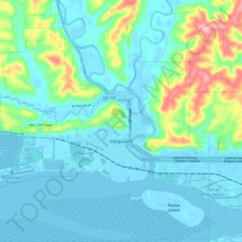
Name: Hoquiam topographic map, elevation, terrain.
Average elevation: 95 ft
Minimum elevation: -23 ft
Maximum elevation: 479 ft
Grays Harbor County trails, hiking, mountain biking, running and outdoor activities
Other topographic maps
Click on a map to view its topography, its elevation and its terrain.
Roosevelt Beach Conservation Area
United States > Washington > Grays Harbor County > Ocean Grove
Average elevation: 59 ft
Roosevelt Beach Conservation Area
United States > Washington > Grays Harbor County > Ocean Grove
Average elevation: 59 ft
McCleary
United States > Washington > Grays Harbor County > McCleary > McCleary
Average elevation: 354 ft