
Make a donation
Gear up for your next adventure:
As an Amazon Associate, this site earns from qualifying purchases at no extra cost to you.
Lohbrügge topographic map
Click on the map to display elevation.
Make a donation
Gear up for your next adventure:
As an Amazon Associate, this site earns from qualifying purchases at no extra cost to you.
About this map
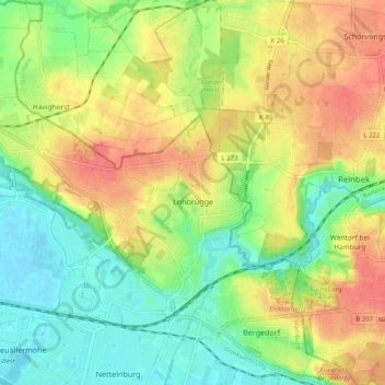
Name: Lohbrügge topographic map, elevation, terrain.
Location: Lohbrügge, Bergedorf, Hamburg, Deutschland (53.48903 10.12237 53.52642 10.22389)
Average elevation: 52 ft
Minimum elevation: -7 ft
Maximum elevation: 174 ft
Make a donation
Gear up for your next adventure:
As an Amazon Associate, this site earns from qualifying purchases at no extra cost to you.
Other topographic maps
Click on a map to view its topography, its elevation and its terrain.
Heuckenlock
Je nach Höhenlage und damit Überflutungshäufigkeit sowie -dauer bei Hochwasser, lassen sich typische Auwald-Vegetationszonen erkennen.
Average elevation: 10 ft
Make a donation
Gear up for your next adventure:
As an Amazon Associate, this site earns from qualifying purchases at no extra cost to you.
Make a donation
Gear up for your next adventure:
As an Amazon Associate, this site earns from qualifying purchases at no extra cost to you.
Övelgönne
Am Elbstrand liegt ein Findling, genannt „Der alte Schwede“, der ein Gewicht von 217 Tonnen, einen Umfang von 19,7 Metern und eine Höhe von 4½ Metern hat. Er wurde bei der Ausbaggerung der Unterelbe gefunden und am 23. Oktober 1999 geborgen.
Average elevation: 56 ft
Make a donation
Gear up for your next adventure:
As an Amazon Associate, this site earns from qualifying purchases at no extra cost to you.
Make a donation
Gear up for your next adventure:
As an Amazon Associate, this site earns from qualifying purchases at no extra cost to you.
Alter Elbpark
Der Alte Elbpark in Hamburg ist eine unter Denkmalschutz stehende öffentliche Grünanlage zwischen den Stadtteilen Neustadt und St. Pauli. Er ist ein Teil der historischen Hamburger Wallanlagen und verbindet die nördlich gelegene Parkanlage Planten un Blomen mit dem Stintfang, einer markanten Anhöhe…
Average elevation: 46 ft
Make a donation
Gear up for your next adventure:
As an Amazon Associate, this site earns from qualifying purchases at no extra cost to you.
Hamburger Stadtpark
Das westliche Ufer des Stadtparksees hatte ein sechs Meter hohes Kaskadenbauwerk, das den Höhenunterschied zwischen der Liegewiese und dem See architektonisch fasste. Es wurde 1952 abgerissen und ist noch in Teilen erhalten.
Average elevation: 49 ft
Neuwerk
Eine 1926 errichtete kleine Windanlage hatte nur kurz Bestand und nach dem Krieg war Diesel zum Betrieb der Leuchtturmgeneratoren knapp. Im Auftrag des Überlandwerk Nord-Hannover (ÜNH) erbaute Dimitri Stein eines der ersten deutschen Windkraftwerke. Es sollte 80 % des Energiebedarfs der Insel decken und…
Average elevation: 0 ft
Make a donation
Gear up for your next adventure:
As an Amazon Associate, this site earns from qualifying purchases at no extra cost to you.
Make a donation
Gear up for your next adventure:
As an Amazon Associate, this site earns from qualifying purchases at no extra cost to you.
Fischbeker Heide
Die Fischbeker Heide ist ein 773 Hektar großes Naturschutz- und FFH-Gebiet im Südwesten Hamburgs in den Stadtteilen Neugraben-Fischbek und Hausbruch. Es umfasst eine Heide- und Waldlandschaft, die einschließlich der zum Schutzgebiet gehörenden Neugrabener Heide nach der Lüneburger Heide die zweitgrößte…
Average elevation: 180 ft
Make a donation
Gear up for your next adventure:
As an Amazon Associate, this site earns from qualifying purchases at no extra cost to you.
Make a donation
Gear up for your next adventure:
As an Amazon Associate, this site earns from qualifying purchases at no extra cost to you.