
Make a donation
Gear up for your next adventure:
As an Amazon Associate, this site earns from qualifying purchases at no extra cost to you.
Tarvisio topographic map
Click on the map to display elevation.
Make a donation
Gear up for your next adventure:
As an Amazon Associate, this site earns from qualifying purchases at no extra cost to you.
Tarvisio
Despite the modest elevation, the city has a continental climate with cold winters (lowest recorded temperature is −23 °C (−9 °F) in January 1985). Summers can be very hot (highest recorded temperature of 37 °C (99 °F) in July 1983).
Make a donation
Gear up for your next adventure:
As an Amazon Associate, this site earns from qualifying purchases at no extra cost to you.
About this map
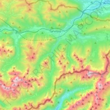
Name: Tarvisio topographic map, elevation, terrain.
Location: Tarvisio, Udine, Friuli – Venezia Giulia, 33018, Italy (46.38297 13.47846 46.55363 13.71730)
Average elevation: 4,160 ft
Minimum elevation: 1,795 ft
Maximum elevation: 8,737 ft
Make a donation
Gear up for your next adventure:
As an Amazon Associate, this site earns from qualifying purchases at no extra cost to you.