

Saas-Fee topographic map
Click on the map to display elevation.
Saas-Fee
Saas-Fee offers 22 lifts, including 3 cable cars, 1 funicular railway (Metro Alpin), 5 gondolas (1 dedicated to walkers), 2 chairlifts, the remainder being surface lifts (draglifts). The ski run has a vertical drop of 1,800 m (5,906 ft), a top elevation of 3,600 m (11,811 ft) and covers 150 km (93 mi) (80 km (50 mi) beginner, 45 km (28 mi) intermediate, 25 km (16 mi) advanced). Other activities include paragliding, hang gliding, and tobogganing.
About this map
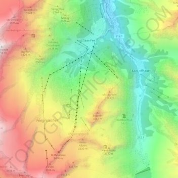
Name: Saas-Fee topographic map, elevation, terrain.
Location: Saas-Fee, Visp, Wallis, 3906, Switzerland (46.04609 7.85721 46.12524 7.94542)
Average elevation: 8,770 ft
Minimum elevation: 5,118 ft
Maximum elevation: 14,016 ft
Other topographic maps
Click on a map to view its topography, its elevation and its terrain.
Zermatt
Switzerland > Wallis > Visp > Zermatt > Zermatt
It lies at the upper end of Mattertal at an elevation of 1,620 m (5,310 ft), at the foot of Switzerland's highest peaks. It lies about 10 km (6.2 mi) from the over 3,292 m (10,801 ft) high Theodul Pass bordering Italy. Zermatt is the southernmost commune of the German Sprachraum.
Average elevation: 8,100 ft