Geolocate

Salton topographic map

Click on the map to display elevation.

About this map

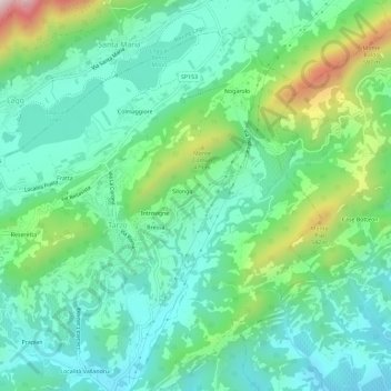
Name: Salton topographic map, elevation, terrain.

Location: Salton, Tarzo, Province of Treviso, Veneto, 31029, Italy (45.95649 12.22313 45.99649 12.26313)

Average elevation: 968 ft

Minimum elevation: 463 ft

Maximum elevation: 2,388 ft

Gear up for your next adventure:

🪶Survival Guide Book - Expert advice for emergency preparedness
📷Action Cameras - Rugged cameras to document your journeys across rugged terrain
GPS Sports Watch - GPS watch for running, hiking and training
🏔️Mountain Trail Maps - High‑detail maps for popular peaks
🎒Trail Energy Bars - High‑calorie bars for hiking energy

As an Amazon Associate, this site earns from qualifying purchases at no extra cost to you.