
Make a donation
Gear up for your next adventure:
As an Amazon Associate, this site earns from qualifying purchases at no extra cost to you.
Campitello Matese topographic map
Click on the map to display elevation.
Make a donation
Gear up for your next adventure:
As an Amazon Associate, this site earns from qualifying purchases at no extra cost to you.
Campitello Matese
Campitello Matese is a location known to cycling fans for being several times during the coming stage of the Giro d'Italia: the first in 1969, the last in 2002. The characteristics of the ascent from San Massimo Campitello (13.5 miles long and 850 m in altitude, average slope of 6.4%) make it one of the most challenging uphill finishes of the Apennines.
Make a donation
Gear up for your next adventure:
As an Amazon Associate, this site earns from qualifying purchases at no extra cost to you.
About this map
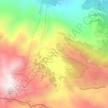
Name: Campitello Matese topographic map, elevation, terrain.
Average elevation: 4,626 ft
Minimum elevation: 2,257 ft
Maximum elevation: 6,686 ft
Make a donation
Gear up for your next adventure:
As an Amazon Associate, this site earns from qualifying purchases at no extra cost to you.