
Make a donation
Gear up for your next adventure:
As an Amazon Associate, this site earns from qualifying purchases at no extra cost to you.
Tarpon topographic map
Click on the map to display elevation.
Make a donation
Gear up for your next adventure:
As an Amazon Associate, this site earns from qualifying purchases at no extra cost to you.
About this map
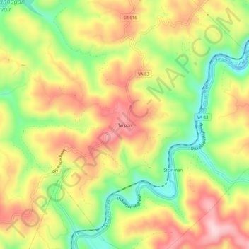
Name: Tarpon topographic map, elevation, terrain.
Location: Tarpon, Dickenson County, Virginia, 24226, United States (37.16594 -82.37126 37.20594 -82.33126)
Average elevation: 1,699 ft
Minimum elevation: 1,283 ft
Maximum elevation: 2,090 ft
Dickenson County trails, hiking, mountain biking, running and outdoor activities
Make a donation
Gear up for your next adventure:
As an Amazon Associate, this site earns from qualifying purchases at no extra cost to you.
Other topographic maps
Click on a map to view its topography, its elevation and its terrain.
Clintwood
United States > Virginia > Dickenson County
Owing to its altitude, Clintwood has an oceanic climate (Köppen climate classification Cfb).
Average elevation: 1,873 ft