
Kabwum topographic map
Interactive map
Click on the map to display elevation.
About this map
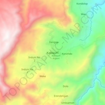
Name: Kabwum topographic map, elevation, terrain.
Location: Kabwum, Morobe, Momase Region, Papua New Guinea (-6.19529 147.14936 -6.11529 147.22936)
Average elevation: 5,489 ft
Minimum elevation: 2,408 ft
Maximum elevation: 8,976 ft
Other topographic maps
Click on a map to view its topography, its elevation and its terrain.
Menya
Papua New Guinea > Morobe > Menyamya District
Menya, Menyamya District, Morobe, Momase Region, Papua New Guinea
Average elevation: 6,024 ft
Salamaua
Salamaua, Morobe, Momase Region, Papua New Guinea
Average elevation: 36 ft
Me'enaka
Me'enaka, Morobe, Momase Region, Papua New Guinea
Average elevation: 5,069 ft
Sawana
Sawana, Morobe, Momase Region, Papua New Guinea
Average elevation: 4,544 ft
Popoe
Papua New Guinea > Morobe > Popoe
Popoe, Morobe, Momase Region, Papua New Guinea
Average elevation: 335 ft
Kabwum District
Kabwum District, Morobe, Momase Region, Papua New Guinea
Average elevation: 2,484 ft
Finschhafen District
Papua New Guinea > Morobe > Finschhafen District
Finschhafen District, Morobe, Momase Region, Papua New Guinea
Average elevation: 1,611 ft
Lae
Papua New Guinea > Morobe > Lae District
Lae, Lae District, Morobe, Momase Region, Papua New Guinea
Average elevation: 531 ft
Sialum Island
Sialum Island, Finschhafen District, Morobe, Momase Region, Papua New Guinea
Average elevation: 1,860 ft
Umboi Island
Umboi Island, Finschhafen District, Morobe, Momase Region, Papua New Guinea
Average elevation: 581 ft