
Make a donation
Gear up for your next adventure:
As an Amazon Associate, this site earns from qualifying purchases at no extra cost to you.
Hartlanden topographic map
Click on the map to display elevation.
Make a donation
Gear up for your next adventure:
As an Amazon Associate, this site earns from qualifying purchases at no extra cost to you.
Hartlanden
Auf einer kleinen Anhöhe des Aurachtals, etwa sechs Kilometer südwestlich der Domstadt Bamberg, liegt abseits belebter Straßen die Ortschaft Hartlanden. Der Birkacher Wald und das Spitalholz grenzen als Ausläufer des Steigerwalds an die Hartlandener Flur. Ein namenloser Bach entspringt im Südwesten, speist den Dorfweiher und mündet nördlich vom Stangersberg in einen Vorfluter der Aurach. Im Osten ist der Ort fast mit dem benachbarten Dellerhof verbunden. Hartlanden liegt im Dorfkern auf einer Höhe von 274 m und in der Rothenbühlstraße auf 296 m. Die Hartlandener Flur hat eine Höhe zwischen 270 m im Wiesengrund im Osten und 335 m im Wald bei Rothenbühl im Westen. Durch den wenig ertragreichen Boden sind die Erträge in der Landwirtschaft nur mäßig.
Make a donation
Gear up for your next adventure:
As an Amazon Associate, this site earns from qualifying purchases at no extra cost to you.
About this map
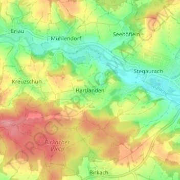
Name: Hartlanden topographic map, elevation, terrain.
Average elevation: 974 ft
Minimum elevation: 830 ft
Maximum elevation: 1,129 ft
Make a donation
Gear up for your next adventure:
As an Amazon Associate, this site earns from qualifying purchases at no extra cost to you.
Other topographic maps
Click on a map to view its topography, its elevation and its terrain.