
Make a donation
Gear up for your next adventure:
As an Amazon Associate, this site earns from qualifying purchases at no extra cost to you.
Assesse topographic map
Click on the map to display elevation.
Make a donation
Gear up for your next adventure:
As an Amazon Associate, this site earns from qualifying purchases at no extra cost to you.
Assesse
Assesse is een plaats en gemeente in de Belgische provincie Namen. De gemeente telt ruim 7.000 inwoners. Assesse ligt op een hoogte van 268 meter. Assesse ligt het ongeveer tien kilometer ten zuidoosten van de provinciehoofdstad Namen, op de aansluiting van de belangrijke Ardense wegen A4/E411 en N4.
Make a donation
Gear up for your next adventure:
As an Amazon Associate, this site earns from qualifying purchases at no extra cost to you.
About this map
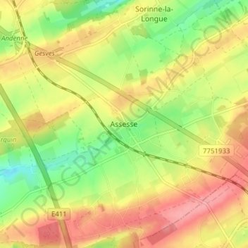
Name: Assesse topographic map, elevation, terrain.
Location: Assesse, Namen, Wallonië, 5330, België (50.35183 5.00176 50.39183 5.04176)
Average elevation: 876 ft
Minimum elevation: 715 ft
Maximum elevation: 1,020 ft
Make a donation
Gear up for your next adventure:
As an Amazon Associate, this site earns from qualifying purchases at no extra cost to you.