Geolocate

Marzano Appio topographic map

Click on the map to display elevation.

About this map

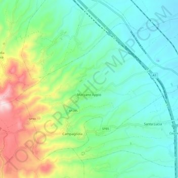
Name: Marzano Appio topographic map, elevation, terrain.

Location: Marzano Appio, Caserta, Campania, Italy (41.28880 14.00082 41.34910 14.10084)

Average elevation: 1,007 ft

Minimum elevation: 479 ft

Maximum elevation: 2,402 ft

Other topographic maps

Click on a map to view its topography, its elevation and its terrain.

Località Aurno

Italy > Campania > Caserta > Marcianise

Average elevation: 72 ft

Ventaroli

Italy > Campania > Caserta > Carinola

Average elevation: 512 ft

Cappelle

Italy > Campania > Caserta > Teano

Average elevation: 997 ft

Talanico

Italy > Campania > Caserta > San Felice a Cancello

Average elevation: 1,010 ft

Destra Volturno

Italy > Campania > Caserta > Castel Volturno

Average elevation: 3 ft

San Leucio-complex

Italy > Campania > Caserta > Caserta

Average elevation: 558 ft

Brezza

Italy > Campania > Caserta

Average elevation: 43 ft

Brezza

Italy > Campania > Caserta

Average elevation: 43 ft

Campo Felice

Italy > Campania > Caserta > Cellole

Average elevation: 30 ft

Gear up for your next adventure:

🔭Stargazing Telescopes - Perfect for camping in low-light pollution areas shown on maps
📌Outdoor GPS Map App - Apps and devices for digital topographic navigation
👓Polarized Sunglasses - Outdoor sunglasses for glare reduction
🚪Portable Camp Chair - Foldable chair for comfort at camp
🪶Trail Camera - Capture wildlife on your hikes

As an Amazon Associate, this site earns from qualifying purchases at no extra cost to you.