
Make a donation
Gear up for your next adventure:
As an Amazon Associate, this site earns from qualifying purchases at no extra cost to you.
Beynost topographic map
Click on the map to display elevation.
Make a donation
Gear up for your next adventure:
As an Amazon Associate, this site earns from qualifying purchases at no extra cost to you.
Beynost
Le tableau suivant donne les moyennes mensuelles de température et de précipitations pour la station de Lyon-Bron recueillies sur la période 1961 - 1990. La station météo de Lyon Bron est située à environ 20 km à « vol d'oiseau » de Beynost. Elle est située à une altitude de 200 m.
Make a donation
Gear up for your next adventure:
As an Amazon Associate, this site earns from qualifying purchases at no extra cost to you.
About this map
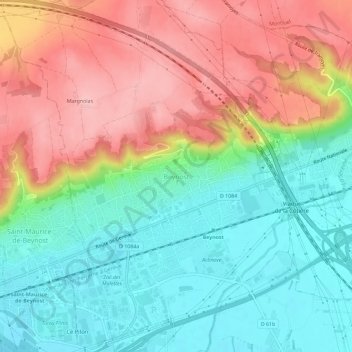
Name: Beynost topographic map, elevation, terrain.
Average elevation: 781 ft
Minimum elevation: 564 ft
Maximum elevation: 1,066 ft
Make a donation
Gear up for your next adventure:
As an Amazon Associate, this site earns from qualifying purchases at no extra cost to you.