Geolocate

Taranto topographic map

Click on the map to display elevation.

About this map

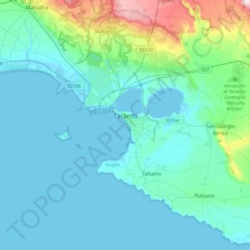
Name: Taranto topographic map, elevation, terrain.

Location: Taranto, Apulia, Italy (40.33016 17.11655 40.59152 17.47272)

Average elevation: 135 ft

Minimum elevation: -13 ft

Maximum elevation: 988 ft

Other topographic maps

Click on a map to view its topography, its elevation and its terrain.

Marinara

Italy > Apulia > Taranto > Mottola

Average elevation: 856 ft

Saturo

Italy > Apulia > Taranto > Leporano

Average elevation: 39 ft

Gear up for your next adventure:

📻Weather Alert Radios - Stay informed of storm risks while off-the-grid
❄️Traction Cleats - Prevent slips on icy trails during winter hikes
📶Satellite Messenger - Communication device off‑grid
💧Water Purification System - Clean water on the trail with reliable purifiers
🪶Paracord Bracelet - Survival bracelet with built‑in tools

As an Amazon Associate, this site earns from qualifying purchases at no extra cost to you.