Geolocate

Ridgefield topographic map

Click on the map to display elevation.

About this map

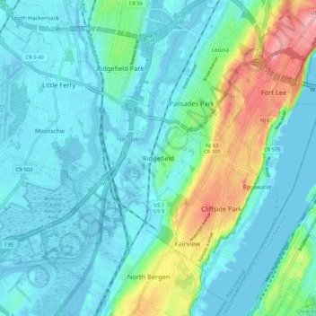
Name: Ridgefield topographic map, elevation, terrain.

Location: Ridgefield, Bergen County, New Jersey, 97657, United States (40.79427 -74.04875 40.87427 -73.96875)

Average elevation: 79 ft

Minimum elevation: -13 ft

Maximum elevation: 384 ft

Bergen County trails, hiking, mountain biking, running and outdoor activities

Gear up for your next adventure:

🌐World Map Poster - Decorative world maps with topographic info
🎒Hydration Pack - Hands‑free water reservoir for long hikes
🔋Solar Power Banks - Keep your GPS and phone charged in remote wilderness areas
🎁Geography Themed Gifts - Unique gift ideas for map lovers and geography enthusiasts
Camping Coffee Makers - Enjoy premium coffee at the summit or campsite

As an Amazon Associate, this site earns from qualifying purchases at no extra cost to you.