
Thank you for supporting this site ❤️
Make a donation
Make a donation
Gear up for your next adventure:
As an Amazon Associate, this site earns from qualifying purchases at no extra cost to you.
A Grova topographic map
Click on the map to display elevation.
Thank you for supporting this site ❤️
Make a donation
Make a donation
Gear up for your next adventure:
As an Amazon Associate, this site earns from qualifying purchases at no extra cost to you.
About this map
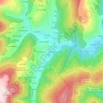
Name: A Grova topographic map, elevation, terrain.
Location: A Grova, Riotorto, Meira, Lugo, Galicia, 27743, España (43.31979 -7.28234 43.35979 -7.24234)
Average elevation: 1,076 ft
Minimum elevation: 436 ft
Maximum elevation: 2,001 ft
Thank you for supporting this site ❤️
Make a donation
Make a donation
Gear up for your next adventure:
As an Amazon Associate, this site earns from qualifying purchases at no extra cost to you.