Tonna topographic map
Interactive map
Click on the map to display elevation.
About this map
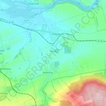
Name: Tonna topographic map, elevation, terrain.
Location: Tonna, Fahner Höhe, Landkreis Gotha, Thuringia, 99958, Germany (51.04772 10.69488 51.11184 10.78391)
Average elevation: 748 ft
Minimum elevation: 545 ft
Maximum elevation: 1,375 ft
Other topographic maps
Click on a map to view its topography, its elevation and its terrain.
Schwabhausen
Germany > Thuringia > Landkreis Gotha
Schwabhausen, Drei Gleichen, Landkreis Gotha, Thuringia, Germany
Average elevation: 1,155 ft
Ohrdruf
Germany > Thuringia > Landkreis Gotha
Ohrdruf, Landkreis Gotha, Thuringia, 99885, Germany
Average elevation: 1,699 ft
Burgtonna
Germany > Thuringia > Landkreis Gotha
Burgtonna, Tonna, Fahner Höhe, Landkreis Gotha, Thuringia, 99958, Germany
Average elevation: 768 ft
Gotha
Germany > Thuringia > Landkreis Gotha
Gotha, Landkreis Gotha, Thuringia, 99867, Germany
Average elevation: 1,050 ft