Geolocate

Rome topographic map

Click on the map to display elevation.

About this map

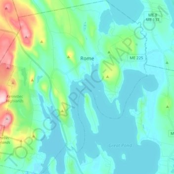
Name: Rome topographic map, elevation, terrain.

Location: Rome, Kennebec County, Maine, United States (44.51231 -69.94754 44.62152 -69.81657)

Average elevation: 387 ft

Minimum elevation: 230 ft

Maximum elevation: 1,168 ft

Kennebec County trails, hiking, mountain biking, running and outdoor activities

Other topographic maps

Click on a map to view its topography, its elevation and its terrain.

McGaffey Mountain

United States > Maine > Kennebec County > Vienna

Average elevation: 860 ft

Maranacook Lake

United States > Maine > Kennebec County > Winthrop

Average elevation: 299 ft

Gear up for your next adventure:

📶Satellite Messenger - Communication device off‑grid
📦Dry Bags Set - Waterproof storage for electronics and clothes
🦶Carbon Trekking Poles - Reduce knee impact on steep descents with ultra-light poles
🌡️Portable Weather Meter - Track weather conditions on the trail
🦟Ultrasonic Repellers - Create a bug-free zone at your camp or rest stop

As an Amazon Associate, this site earns from qualifying purchases at no extra cost to you.