
Make a donation
Gear up for your next adventure:
As an Amazon Associate, this site earns from qualifying purchases at no extra cost to you.
Uztegui topographic map
Click on the map to display elevation.
Make a donation
Gear up for your next adventure:
As an Amazon Associate, this site earns from qualifying purchases at no extra cost to you.
Uztegui
La localidad de Uztegui está situada en la parte occidental del municipio de Araiz a una altitud de 310 m s. n. m. Su término concejil tiene una superficie de 3,538 km² y limita al norte con el concejo de Azcárate; al este con el de Arriba-Atallo y el municipio de Betelu; al sur con los concejos de Inza y Gainzal y al oeste con la Comunidad e Amézqueta y Ordicia (Guipúzcoa).
Make a donation
Gear up for your next adventure:
As an Amazon Associate, this site earns from qualifying purchases at no extra cost to you.
About this map
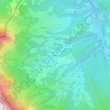
Name: Uztegui topographic map, elevation, terrain.
Location: Uztegui, Araiz, Larraun-Leitzaldea, Navarra, 31891, España (43.00489 -2.02634 43.04489 -1.98634)
Average elevation: 1,549 ft
Minimum elevation: 689 ft
Maximum elevation: 4,580 ft
Make a donation
Gear up for your next adventure:
As an Amazon Associate, this site earns from qualifying purchases at no extra cost to you.