
Hlohovec topographic map
Interactive map
Click on the map to display elevation.
About this map
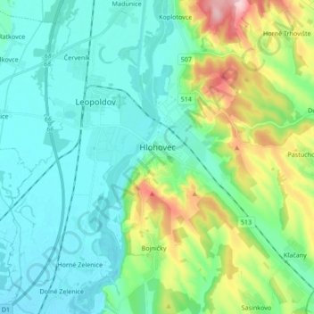
Name: Hlohovec topographic map, elevation, terrain.
Average elevation: 597 ft
Minimum elevation: 436 ft
Maximum elevation: 1,132 ft
Other topographic maps
Click on a map to view its topography, its elevation and its terrain.
Dolné Zelenice
Slovakia > Region of Trnava > District of Hlohovec
Dolné Zelenice, District of Hlohovec, Region of Trnava, Western Slovakia, 920 52, Slovakia
Average elevation: 449 ft