
Thank you for supporting this site ❤️
Make a donation
Make a donation
Gear up for your next adventure:
As an Amazon Associate, this site earns from qualifying purchases at no extra cost to you.
Barcarrota topographic map
Click on the map to display elevation.
Thank you for supporting this site ❤️
Make a donation
Make a donation
Gear up for your next adventure:
As an Amazon Associate, this site earns from qualifying purchases at no extra cost to you.
About this map
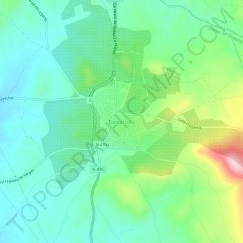
Name: Barcarrota topographic map, elevation, terrain.
Location: Barcarrota, Llanos de Olivenza, Badajoz, Extremadura, España (38.49595 -6.86929 38.53595 -6.82929)
Average elevation: 1,558 ft
Minimum elevation: 1,335 ft
Maximum elevation: 2,142 ft
Thank you for supporting this site ❤️
Make a donation
Make a donation
Gear up for your next adventure:
As an Amazon Associate, this site earns from qualifying purchases at no extra cost to you.