
Wolverton topographic map
Click on the map to display elevation.
About this map
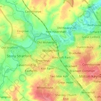
Name: Wolverton topographic map, elevation, terrain.
Average elevation: 269 ft
Minimum elevation: 171 ft
Maximum elevation: 390 ft
Other topographic maps
Click on a map to view its topography, its elevation and its terrain.
Willen Lake
United Kingdom > England > City of Milton Keynes > Milton Keynes > Monkston
Average elevation: 220 ft
Caldecotte Lake
United Kingdom > England > City of Milton Keynes > Milton Keynes > Fenny Stratford
Average elevation: 246 ft
Stantonbury
United Kingdom > England > City of Milton Keynes > Milton Keynes
Average elevation: 279 ft
Milton Keynes
United Kingdom > England > City of Milton Keynes > Milton Keynes
Average elevation: 295 ft
Furzton Lake
United Kingdom > England > City of Milton Keynes > Milton Keynes > Bletchley
Average elevation: 305 ft
Shenley Church End
United Kingdom > England > City of Milton Keynes > Milton Keynes
Average elevation: 322 ft
Walton Lake
United Kingdom > England > City of Milton Keynes > Milton Keynes > Monkston
Average elevation: 240 ft
Whitehouse Park
United Kingdom > England > City of Milton Keynes > Milton Keynes > Wolverton
Average elevation: 325 ft