
Make a donation
Gear up for your next adventure:
As an Amazon Associate, this site earns from qualifying purchases at no extra cost to you.
Valanjou topographic map
Click on the map to display elevation.
Make a donation
Gear up for your next adventure:
As an Amazon Associate, this site earns from qualifying purchases at no extra cost to you.
Valanjou
L'altitude de la commune varie de 44 à 116 mètres, et son territoire s'étend sur près de 56 km2 (5 586 hectares).
Make a donation
Gear up for your next adventure:
As an Amazon Associate, this site earns from qualifying purchases at no extra cost to you.
About this map
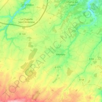
Name: Valanjou topographic map, elevation, terrain.
Average elevation: 289 ft
Minimum elevation: 112 ft
Maximum elevation: 528 ft
Make a donation
Gear up for your next adventure:
As an Amazon Associate, this site earns from qualifying purchases at no extra cost to you.
Other topographic maps
Click on a map to view its topography, its elevation and its terrain.
La Bordellière
France > Pays de la Loire > Maine-et-Loire > Chemillé-en-Anjou
Average elevation: 502 ft
Make a donation
Gear up for your next adventure:
As an Amazon Associate, this site earns from qualifying purchases at no extra cost to you.
Le Jeu
France > Pays de la Loire > Maine-et-Loire > Chemillé-en-Anjou > Moulin de Grouteau
Average elevation: 328 ft
La Gilardière
France > Pays de la Loire > Maine-et-Loire > Chemillé-en-Anjou
Average elevation: 259 ft
La Chalouserie
France > Pays de la Loire > Maine-et-Loire > Chemillé-en-Anjou
Average elevation: 522 ft
Make a donation
Gear up for your next adventure:
As an Amazon Associate, this site earns from qualifying purchases at no extra cost to you.
Les Fossés Ayrault
France > Pays de la Loire > Maine-et-Loire > Chemillé-en-Anjou
Average elevation: 354 ft
La Hunaudière
France > Pays de la Loire > Maine-et-Loire > Chemillé-en-Anjou
Average elevation: 551 ft
Make a donation
Gear up for your next adventure:
As an Amazon Associate, this site earns from qualifying purchases at no extra cost to you.
La Cheminerie
France > Pays de la Loire > Maine-et-Loire > Chemillé-en-Anjou
Average elevation: 538 ft
Make a donation
Gear up for your next adventure:
As an Amazon Associate, this site earns from qualifying purchases at no extra cost to you.
La Gobardière
France > Pays de la Loire > Maine-et-Loire > Chemillé-en-Anjou
Average elevation: 344 ft
La Haute Garde
France > Pays de la Loire > Maine-et-Loire > Chemillé-en-Anjou
Average elevation: 476 ft
Make a donation
Gear up for your next adventure:
As an Amazon Associate, this site earns from qualifying purchases at no extra cost to you.
L'Aulnay Pichon
France > Pays de la Loire > Maine-et-Loire > Chemillé-en-Anjou
Average elevation: 344 ft
Make a donation
Gear up for your next adventure:
As an Amazon Associate, this site earns from qualifying purchases at no extra cost to you.
La Chapelle
France > Pays de la Loire > Maine-et-Loire > Chemillé-en-Anjou > La Jumellière
Average elevation: 240 ft
Peleau
France > Pays de la Loire > Maine-et-Loire > Chemillé-en-Anjou > Peleau
Average elevation: 276 ft
Make a donation
Gear up for your next adventure:
As an Amazon Associate, this site earns from qualifying purchases at no extra cost to you.
La Grande Touche
France > Pays de la Loire > Maine-et-Loire > Chemillé-en-Anjou
Average elevation: 469 ft
Les Ratelières
France > Pays de la Loire > Maine-et-Loire > Chemillé-en-Anjou > La Jumellière
Average elevation: 279 ft