
Thank you for supporting this site ❤️
Make a donation
Make a donation
Gear up for your next adventure:
As an Amazon Associate, this site earns from qualifying purchases at no extra cost to you.
Sandomierz topographic map
Click on the map to display elevation.
Thank you for supporting this site ❤️
Make a donation
Make a donation
Gear up for your next adventure:
As an Amazon Associate, this site earns from qualifying purchases at no extra cost to you.
About this map
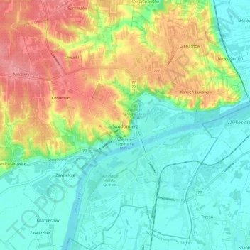
Name: Sandomierz topographic map, elevation, terrain.
Location: Sandomierz, Sandomierz County, Holy Cross Voivodeship, Poland (50.64159 21.70037 50.71757 21.79382)
Average elevation: 554 ft
Minimum elevation: 453 ft
Maximum elevation: 728 ft
Thank you for supporting this site ❤️
Make a donation
Make a donation
Gear up for your next adventure:
As an Amazon Associate, this site earns from qualifying purchases at no extra cost to you.