
Ciales topographic map
Click on the map to display elevation.
About this map
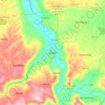
Name: Ciales topographic map, elevation, terrain.
Location: Ciales, Puerto Rico, 00638, United States (18.29660 -66.50839 18.37660 -66.42839)
Average elevation: 620 ft
Minimum elevation: 56 ft
Maximum elevation: 1,286 ft
Ciales trails, hiking, mountain biking, running and outdoor activities
Other topographic maps
Click on a map to view its topography, its elevation and its terrain.
Bosque Estatal Los Tres Picachos
United States > Puerto Rico > Ciales > Jayuya
Average elevation: 2,352 ft