
Make a donation
Gear up for your next adventure:
As an Amazon Associate, this site earns from qualifying purchases at no extra cost to you.
Hobart topographic map
Click on the map to display elevation.
Make a donation
Gear up for your next adventure:
As an Amazon Associate, this site earns from qualifying purchases at no extra cost to you.
Hobart
Although Hobart itself rarely receives snow during the winter due to the foehn effect created by the Central Highlands (the city's geographic position causes a rainshadow), the adjacent Kunanyi/Mount Wellington is frequently seen with a snowcap throughout the year including in summer. During the 20th century, the city itself has received snowfalls at sea level on average only once every 5 years; however, outer suburbs lying higher on the slopes of Mount Wellington receive snow more often, owing to the more exposed position coupled with them resting at higher altitude. These snow-bearing winds often carry on through Tasmania and Victoria to the Snowy Mountains in Victoria and southern New South Wales.
Make a donation
Gear up for your next adventure:
As an Amazon Associate, this site earns from qualifying purchases at no extra cost to you.
About this map
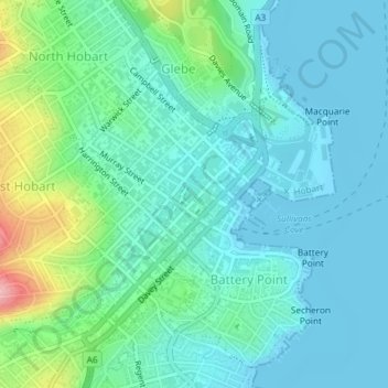
Name: Hobart topographic map, elevation, terrain.
Location: Hobart, City of Hobart, Tasmania, 7000, Australia (-42.89164 147.31561 -42.87305 147.34150)
Average elevation: 102 ft
Minimum elevation: -7 ft
Maximum elevation: 482 ft
Make a donation
Gear up for your next adventure:
As an Amazon Associate, this site earns from qualifying purchases at no extra cost to you.
Other topographic maps
Click on a map to view its topography, its elevation and its terrain.
Make a donation
Gear up for your next adventure:
As an Amazon Associate, this site earns from qualifying purchases at no extra cost to you.
Make a donation
Gear up for your next adventure:
As an Amazon Associate, this site earns from qualifying purchases at no extra cost to you.
Make a donation
Gear up for your next adventure:
As an Amazon Associate, this site earns from qualifying purchases at no extra cost to you.