
Make a donation
Gear up for your next adventure:
As an Amazon Associate, this site earns from qualifying purchases at no extra cost to you.
Frederiksted topographic map
Click on the map to display elevation.
Make a donation
Gear up for your next adventure:
As an Amazon Associate, this site earns from qualifying purchases at no extra cost to you.
Frederiksted
Rainforests occur on the western side of St. Croix due to the topography featuring 1,400 foot or 400 metres peaks, which gather moisture from the trade winds. This rainforest climate is unique to the Frederiksted side of St. Croix.
Make a donation
Gear up for your next adventure:
As an Amazon Associate, this site earns from qualifying purchases at no extra cost to you.
About this map
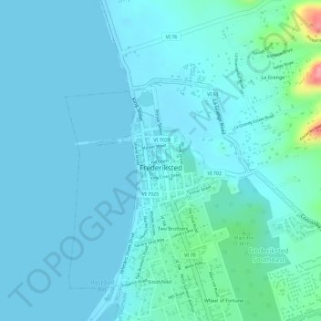
Name: Frederiksted topographic map, elevation, terrain.
Average elevation: 46 ft
Minimum elevation: -7 ft
Maximum elevation: 361 ft
Saint Croix District trails, hiking, mountain biking, running and outdoor activities
Make a donation
Gear up for your next adventure:
As an Amazon Associate, this site earns from qualifying purchases at no extra cost to you.
Other topographic maps
Click on a map to view its topography, its elevation and its terrain.
Contentment
United States > United States Virgin Islands > Saint Croix District
Average elevation: 190 ft
Little Princess South
United States > United States Virgin Islands > Saint Croix District
Average elevation: 167 ft
Clairmont
United States > United States Virgin Islands > Saint Croix District
Average elevation: 167 ft
Morningstar
United States > United States Virgin Islands > Saint Croix District > Morningstar
Average elevation: 223 ft
Make a donation
Gear up for your next adventure:
As an Amazon Associate, this site earns from qualifying purchases at no extra cost to you.