Geolocate

Lone Star topographic map

Click on the map to display elevation.

About this map

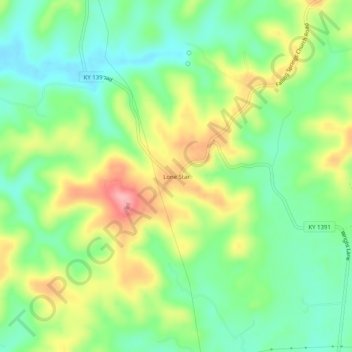
Name: Lone Star topographic map, elevation, terrain.

Location: Lone Star, Hart County, Kentucky, 42713, United States (37.38478 -85.96663 37.42478 -85.92663)

Average elevation: 748 ft

Minimum elevation: 584 ft

Maximum elevation: 1,001 ft

Hart County trails, hiking, mountain biking, running and outdoor activities

Other topographic maps

Click on a map to view its topography, its elevation and its terrain.

Munfordville

United States > Kentucky > Hart County

Average elevation: 627 ft

Horse Cave

United States > Kentucky > Hart County

Average elevation: 679 ft

Bonnieville

United States > Kentucky > Hart County

Average elevation: 696 ft

Gear up for your next adventure:

🪵Folding Camp Saw - Compact saw for wood and campsite work
😴Insulated Sleeping Pads - Compact and warm pads for high-elevation camping
🔦Powerful Headlamps - Ultra-bright hands-free lighting for night navigation
🔭Compact Binoculars - HD vision for scouting terrain and identifying distant landmarks
🧭Map Reading Tools - Tools and kits for map navigation

As an Amazon Associate, this site earns from qualifying purchases at no extra cost to you.