
Make a donation
Gear up for your next adventure:
As an Amazon Associate, this site earns from qualifying purchases at no extra cost to you.
Colcapampa topographic map
Click on the map to display elevation.
Make a donation
Gear up for your next adventure:
As an Amazon Associate, this site earns from qualifying purchases at no extra cost to you.
About this map
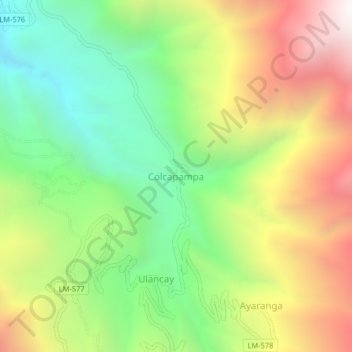
Name: Colcapampa topographic map, elevation, terrain.
Location: Colcapampa, Paccho, Huaura, Lima, Peru (-10.93902 -76.97001 -10.89902 -76.93001)
Average elevation: 9,101 ft
Minimum elevation: 6,460 ft
Maximum elevation: 12,615 ft
Make a donation
Gear up for your next adventure:
As an Amazon Associate, this site earns from qualifying purchases at no extra cost to you.
Other topographic maps
Click on a map to view its topography, its elevation and its terrain.
Lima
Der Distrikt Lima, auch Cercado de Lima, ist einer der 43 Stadtbezirke der Region Lima Metropolitana in Peru. Er umfasst eine Fläche von 21,98 km². Beim Zensus 2017 wurden 268.352 Einwohner gezählt. Im Jahr 1993 lag die Einwohnerzahl bei 340.422, im Jahr 2007 bei 299.493. Der Distrikt wurde 1823 gegründet.…
Average elevation: 463 ft
San Martín de Porres
Der Distrikt San Martín de Porres ist einer der 43 Stadtbezirke der Region Lima Metropolitana in Peru. Er hat eine Fläche von 36,91 km². Beim Zensus 2017 wurden 654.083 Einwohner gezählt. Im Jahr 1993 lag die Einwohnerzahl bei 380.384, im Jahr 2007 bei 579.561. Der Distrikt wurde am 22. Mai 1950…
Average elevation: 180 ft
Make a donation
Gear up for your next adventure:
As an Amazon Associate, this site earns from qualifying purchases at no extra cost to you.
Make a donation
Gear up for your next adventure:
As an Amazon Associate, this site earns from qualifying purchases at no extra cost to you.
Lunahuaná
Der Distrikt Lunahuaná liegt in der Provinz Cañete der Region Lima im zentralen Westen Perus. Der Distrikt wurde am 4. August 1821 gegründet. Er hat eine Fläche von 500,33 km². Beim Zensus 2017 lebten 4393 Einwohner im Distrikt. Im Jahr 1993 betrug die Einwohnerzahl 4233, im Jahr 2007 4567.…
Average elevation: 4,311 ft
Make a donation
Gear up for your next adventure:
As an Amazon Associate, this site earns from qualifying purchases at no extra cost to you.